The Zelienople Airport and the road surrounding it, are under construction, but not for the reasons that some area residents speculate.
Theories and rumors would have drivers believe that the runway is being expanded for FedEx and UPS type planes for their nearby fulfillment centers, but Airport Manager, David Holman said that’s simply not true.
“It’s complete rumor mill about FedEx or UPS using the airport,” Holman said. “The project is for obstruction removal in the approach surface of the airport. It does shift the runway further north, although the overall length is only 67 feet longer. It’s a safety required project for the airport and Penndot Highways. It will not be used for landing of larger aircraft than use the airport presently.”
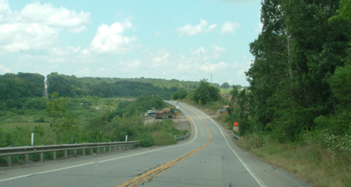
The runway is currently closed and according to airport officials will likely reopen sometime in mid October. They reported that the Route 288 project completion date is expected to fall sometime into the first quarter 2021 and is subject to weather and the ongoing effects of the pandemic.
Tom Surgalski, Chairman, Zelienople Airport Authority, said the work being done represents two separate projects.
“The runway is being replaced from the base up as it was far beyond its useful life,” Surgalski said.
According to Surgalski, the work on RT 288 involves a number of different State and Federal agencies.
“The relocation of a portion of RT 288 will eliminate a hazardous section of the road as well as provide the Airport with additional runway safety areas,” he said.
According to project plans in the Public Presentation provided by Holman, the following changes will be implemented:
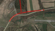
- The Realignment Project of SR 288, Section B04 (Zelienople Road) and SR 1010 (Lake Road) adjacent to the Zelienople Municipal Airport Runway 17 will horizontally realign and vertically lower these highways to accommodate FAA clearance requirements for night-time operations on the Airport’s Runway 17 approach.
- Realignment of 1,740-feet of SR 288 will eliminate a reverse curve posted with an advisory speed limit and improve stopping sight distance to meet the minimum requirements. The highway will be lowered by as much as 50-feet. Realignment of 1,247-feet of SR 1010 includes widening of the lanes from 9-feet to 10-feet and improving the stopping sight distances to meet the minimum requirements. The highway will be lowered by as much as 30-feet. The realignment will relocate the intersection of SR 1010 with SR 0288 from a curved location to a tangent location; the elimination of this curve will improve the intersection sight distance to the south. The intersection will be lowered by 25-feet.
The plan also stated that in order to reduce costs, the Airport Authority is performing excavation operations for the new location of SR 1010 without affecting the highways. The final portion of excavation will require SR 0288 and SR 1010 to be closed.
According the the airport’s website, the Zelienople Airport is a public, general aviation facility owned and operated by the Zelienople Airport Authority (ZAA). The land on which the airport is located was a strip mine in the early 1940’s owned by Tasa Coal. When the coal was depleted and the land partially graded, it was sold to Halstead, Inc. in the late 1940’s for a private landing strip for their company plane. As the original landing strip was grass, it also provided an excellent field for polo matches. As the popularity of general aviation grew, hangars were built, the runway was paved, and it became an airport open to the public in the 1950’s. In 1958 Zelienople Borough formed an Authority and transferred ownership and management from Halstead. In 1973 the Authority was split into two authorities: one for sewage (WBCA – Western Butler Sewer Authority; and the other, what is today, the ZAA (Zelienople Airport Authority).
For more information about the airport, visit the website: http://zelienopleairport.com/

Not related but very close. this realignment of rt288 will make the curve at Old Furnace Rd , which is at the bottom of a steep hill, much sharper.